
Showing posts with label bridges. Show all posts
Showing posts with label bridges. Show all posts
Wednesday, February 1, 2012
Friday, August 26, 2011
PhotoHunt - Symbolic images

The Carroll Creek Community Bridge is painted with many images which are symbolic of the life and history of the area. Here are two of them.

Monday, May 24, 2010
Geometry - Photoshopped lines & arcs
 Marianne took some shots of the Delaware Memorial Bridge last summer as we drove north on I-95. With just a gray bridge and gray sky, I did a little work with PhotoShop to add interest to this image. Applying glowing edges created the black and white image. And replacing color added some flair to the lines and curves of the bridge.
Monday, May 17, 2010
Geometry - on a bridge
 There are many geometrical shapes on this iron and wood footbridge over Carroll Creek in Frederick: spheres, cylinders, swirls, lines, arcs, etc. This is the bridge I posted Friday for Reflections.
To see more geometry, go to Katney's Kaboodle.


Monday, March 8, 2010
Geometry - Cylinder and I-beams
 Here is a cylinder that supports a pedestrian bridge over Carroll Creek in Frederick. To see the topside of the cylinder look here.
To see more geometry, go to Katney's Kaboodle.
Monday, March 1, 2010
Geometry - Arches, shape of strength
 Arches have been used for centuries to build structures that supported heavy loads. Here are two examples. Above is a pedestrian bridge over Carroll Creek in downtown Frederick built about 5 years ago. Below is the Legore Bridge over the Monocacy River in the northern part of the county. James Legore built the bridge in 1900 to speed deliveries of stone from his quarry to customers in Pennsylvania. To see more geometry, go to Katney's Kaboodle.
Monday, November 2, 2009
Historic Bridges - Loy's Station
 Approach from the south
Loy's Station Covered Bridge is one of three remaining covered bridges in Frederick County. This multiple king post bridge was built around 1860 over Owens Creek in the northern part of the county. It was reinforced with steel beams and a center pier on the 1930's; and rehabilitated in 1976. After a fire, it was rebuilt in 1994 with contributions from people of the county. There is a small community park along the creek, making this historic bridge one of the best for parking and photographing. Bring a picnic and enjoy the sun, fresh air and beautiful setting.
 King post detail
 Side view from island in the creek
 South abutment
Monday, October 5, 2009
Potomac River Bridge US 15
 This bridge carries US highway 15 across the Potomac River between Frederick County, MD and Loudoun county, VA. The eight span, metal truss bridge was built in 1939. There are two spans to the right of the above picture. These shots were taken from the Virginia side of the river last March, with a little snow still on the ground.

Monday, August 3, 2009
Historic Bridges - Reich's Ford Road
 South approach
Reich's Ford Road Bridge was built in 1905 by the York Bridge Company. It spans Bush Creek in southern Frederick County. It is a gusset plate pony truss bridge. York Bridge Company built several bridges of this type in Frederick County in the early 1900's.
 North approach
 Upstream view
 Gusset plate
Monday, July 6, 2009
Bridges on the way to Connecticut
After a delightful 3 -week visit with us, including a side trip to NC, we took Elaine back to Connecticut on June 26. The most direct way is to Baltimore and follow I 95/New Jersey Turnpike to New York, then up I-684 to Danbury. Along the way, we cross two significant shipping channels. The first is the Delaware River that serves ports in Philadelphia, New Jersey and Delaware. The second is the Hudson River between New Jersey and New York. It was overcast and hazy for most of the trip and then heavy rain as we drove north from New York City. Traffic was heavy and slow across NYC and with the rain north of the city. It took us 3 hours to go the last 66 miles from the end of the New Jersey Turnpike to Elaine's. My thanks to Marianne who took these shots as I drove.
 Approach to Delaware Memorial Bridge
The Delaware Memorial Bridge is a twin-span, suspension bridge. The first span was completed in 1951 and the second span opened in 1968, as traffic far exceeded the original estimates. Each span carries 4 lanes of traffic. The main spans are 2,150 feet and total length of the bridge is 2.5 miles. The towers are 417 feet high and the bridge is 188 feet above the shipping channel.

 On the north bound span
 The George Washington Bridge is a 14-lane, two-level suspension bridge. The upper level opened in 1931 and the lower level in 1962. The GW bridge towers are 604 feet high and shipping clearance is 212 feet. The length of the bridge is 4,760 feet. There are multiple roads leading to and from the bridge, with a number of merges and possible exits. The bridge is not a place for a timid driver on a Friday afternoon!
 Almost to the bridge
 Lower level of the bridge
 View from bridge south - City of New York on left
Monday, June 1, 2009
Historic Bridges: Bennies Hill Road revisited
 Attaching cables and straps
On May 28, the Bennie's Hill Road Bridge was reset on its abutments. The bridge structure has been resting in the road while the abutments were rebuilt. Some parts of the metal structure were replaced and the bridge repainted. This 94-foot bridge was originally built in 1879 and is listed on the National Register of Historical Places. A large crane was used to lift the bridge, swing it over the creek and lower it onto the abutments. For another view of the bridge in air, see my Thursday post. There is still work to be done before traffic can cross the creek. Floor beams and decking must be replaced and work around the approach completed. I will do another update after the bridge is open to traffic. For more info on this bridge (and other historic bridges) see Historic Bridges of Michigan and Elsewhere.
 Lift off!
 Over the creek
 View of the other side
 Almost there
 In place!
Monday, May 4, 2009
Historic Bridges: Keysville - Four Points
I thoroughly enjoyed RuneE's meme Bridges Between. The meme included the widest definition of the title, with posts on ways of connecting people other than the traditional structure crossing some chasm. I am going to post here a personal theme "Historic Bridges" focusing on bridges in our area that have historical significance. Frederick County has 29 such bridges with spans over 20 feet. There are also other bridges in Maryland that I want to cover. Most of the Frederick County historic bridges were built in the late 1800's or early 1900's. Three are wooden covered bridges; one is a stone arch bridge; and 25 are metal truss bridges. In 1990 the county Department of Highways and Transportation began a program to rehabilitate and preserve these bridges. Some were rehabilited by county crews and contractors were hired for others. The county is planning to keep these bridges open as long as the traffic load does not exceed bridge capacity.
These historic bridges were posted as part of Bridges Between:
These historic bridges were posted as part of Bridges Between:
Roddy Road Covered Bridge posted April 2008
Legore Stone Arch Bridge posted July 2008
Antietam Lower Bridge (aka Burnside's Bridge) posted August 2008
Utica Mills Covered Bridge posted September 2008
Stevens Road Bridge posted December 2008
Bullfrog Road Bridge posted January 2009
Sixes Road Bridge posted February 2009
Bennies Hill Road posted March 2009
In addition, Marianne posted Loy's Station Covered Bridge in September 2007. All are in Frederick County except Antietam Lower Bridge, which is in Washington County on the site of a major Civil War battle.
 Approach
Today's post is the Keysville - Four Points Bridge spanning Tom's Creek in the northern part of Frederick County. This is a Pratt truss bridge. It was built by the Wrought Iron Bridge Company of Canton, Ohio in 1880. It was washed off its abutments by Hurricane Fran in September 1996, lifted out of the creek by a crane, rehabilitated and placed back on its abutments. It reopened to traffic in August 1997. In addition to being a county historic bridge, it is listed in the National Registry of Historic Places.
 View from down stream
 Abutment and bearing detail
 Bottom chord detail
 Wood deck
 Monday, April 6, 2009
Bridges of New York
 In 2007 we visited the Statue of Liberty with 2 of our grandsons. The statue is on Liberty Island in the New York Harbor. It offers a grand view of Manhattan and two of the important bridges of New York. In all there are 8 bridges and 3 tunnels for motor vehicles that cross these two rivers in the city. In addition there are subways and ferries providing transportation.
  The Brooklyn Bridge spans the East River, connecting the boroughs of Manhattan and Brooklyn. In 1857 the New York legislature began consideration of a bill to build such a bridge. The bill passed in 1866 and John Augustus Roebling and Wilhelm Hildenbrand were hired to design the bridge. Work began in 1870 and was opened to traffic on May 24, 1883. Toll for pedestrians was 1 cent on opening day and then 3 cents; vehicles were a nickle. Today there are no tolls. Total length is 6016 feet with a main span of 1595 feet. For a comprehensive history of the bridge see Brooklyn Bridge Facts, History and Information. The towers of the Manhattan Bridge can also be seen beyond the Brooklyn Bridge. For another shot of the Brooklyn Bridge see Mary the Teach's post.
 The (link) Verrazano-Narrows Bridge spans the mouth of the upper New York bay. It connects the New York city boroughs of Brooklyn and Staten Island. It was named for explorer Giovanni da Verrazano, the first European to sail into New York Harbor. The bridge was completed in 1964 and at that time was the longest suspension bridge in the world with a main span of 4,260 feet. The towers are 693 feet high. For more of this trip see My world Tuesday on the April 7.
Saturday, February 7, 2009
PhotoHunt - Bridge
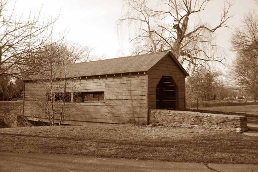
 A covered foot bridge over Carroll Creek in Baker Park. For another view see the header in Marianne's photo blog.
 Monday, December 1, 2008
Bridges Between - Steven's Road Bridge
 Frederick County has 29 historic bridges of 20 feet or more length that span the Monocacy River and various creeks. Three are wooden covered bridges: Roddy Bridge, Utica Bridge and Loy's Station Bridge. One is the Legore stone arch bridge. The others are steel or iron truss bridges. Most of these metal bridges were built in the late 1800's and early 1900's. This one is the Stevens Road Bridge over Hunting Creek. It was built in 1912 and was the first of the historic bridges to be rehabilitated in 1990. Like many others, it is one lane wide even though the road widens to 2 lanes beyond the bridge.


Subscribe to:
Posts (Atom)


